

Full list of Signs erected by the Rural History Buffs
Alphabetical by name, with description and locations.

Amsterdam
Location: north side of 216 Pl., west of house #1072. (N 41° 21.986', W 98° 57.476')
Plotted in 1848 for Dominie Scholte (Pella’s founder). The original plat shows 60 blocks divided into 490 lots with a public square and a city market. At the time a few steamboats were still ascending the Des Moines River. He hoped Amsterdam was destined to become a commercial center. Few plots were sold because of the floods of 1851 and 1852 and the fact that steamboats could no longer navigate the river.

Asbury Methodist Church
Location: 1/4 mile east of 180th Ave. on north side of T-15. (N 41° 20.532', W 92° 59.989')
The church was deeded in 1868 and razed in 1988. It was known as the Asbury Chapel. The church was destroyed by fire on the afternoon of Nov. 20, 1887. The fire originated from sparks landing on the roof during a service.

Attica School Ballfield
Location: 1870 Hwy G76, Attica
Home to the Attica Merchants Men’s Fastpitch Softball team. The team was formed in the 1940s. The last game was played in 1983. During this time many local men took great pride in playing for their team which could include both fathers and sons on the same team. It must be stated that it was a family affair with the mothers and wives of the players being a vital part of every game.
The term fastpitch became a vital clue as to the importance of a good pitcher to the success of a team. It was very common for a great pitcher to strike out 15 to 20 batters in a game. In a pitching duo with two great pitchers the winning score might be 1 to 0 or 2 to 1. Often the score would be less than 5 total points for the two teams.
One of the most successful pitchers to play here was Abie Davis. Abie started his career as a pitcher for the neighboring town of Marysville men’s team at the age of 14. He went on to pitch for several teams in a career that spanned over 35 years. Abie played for Attica 1955-1961 and again in 1964-1967. Abie played an estimated 1,575 games winning 1,400. Abie was inducted into the Des Moines Fast Pitch Hall of Fame in 2005. Abie was inducted into the Iowa Men’s Fastpitch Hall of Fame October 23, 2022.
The Rural History Buffs of Marion County is sponsoring and paying for this sign. Abie was a member and for the whole time was our “sign man“. Having worked as County Engineer for Marion County, he already knew where most of the lost places were located. He would GPS the location and was our liaison with the roads department to get them installed. Thanks, Abie for your contribution to the Buffs, Marion County and the Attica Merchants. Thank you also for a life well lived!!!
Abie Davis 1937-2020

Barnett Coal Co
Location: 20 ft. east of 1741 Newbold Drive access. (N 41°17.744', W 93° 01.129')
Operated from 1936 to 1947 by the Barnett family. Mine # 3 was opened in 1938 by Kendall and Doug Barnett, sons of Jack Barnett, on land owned by the family. Jack Barnett and his sons and son-in-law, Scott Wilson, operated this mine until 1947.

Battle Ridge School
Location: 1998 Dubuque St. (N 41° 27.103', W 92° 58.045')
This school was built on an acre purchased from Mrs. A. P. Hasselman and J. Schippers in 1870. Former students have held several reunions. A two-volume history of the school may be found at the Pella Historical Village. Closed 1960.
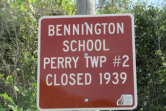
Bennington School
Location: 700 ft east of 40th Ave on south side of Arthur Dr. (N 41° 29.635', W 93° 16.167')
This school was in the town of Bennington which was platted in 1847 but never grew beyond a few houses. In 1915 a couple of students brought what they thought was an empty gun into the school house after shooting rabbits. During recess one of the boys picked up the gun and “just for fun” fired at the new brass door knob blowing the knob and wood into the school yard where students were playing. No one was injured in the early “school shooting”.
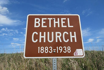
Bethel Church
Location: NW of Jct. G-40 and 105th Ave. (N 41° 24.013', W 93° 09.027')
This church was established in 1882 when Mary and R. R. Stevenson transferred an acre of ground for the 30x40 building which was constructed in 1883. In the late 1890’s a nucleus of four large families each with 9 to 10 children made up the congregation. During WW I it was the township center for holding Red Cross Drives and purchase of War Bonds. A small brick chapel was built in 1931. In the late 1930’s the Church Conference gave it to the township where it became a voting center and meeting place. 1883-1938.

Bethel City
Location: Jct. of Pierce Drive and 23h Ave. (N 41° 16.201', W 92° 54.532')
The first settlers came to this area in 1849. They organized a Sunday School called Bethel. A general store was opened in 1875 and a post office established. Because there was another town in Iowa called Bethel, “City” was added to its name.

Bethel Reformed Church
Location: NW of Jct of 210th Ave. and Coolidge Street. (N 41°27.940', W 93° 56.876')
With 33 charter members, it was started by First Reformed Church of Pella. Many others in the neighborhood became members over the years. The Bethel Reformed Ladies Aid continued to meet several years after the demise of the building. 1866-1937.

Beulah Methodist Chapel
Location: South side Oregon Dr. at Jct of 165th Ave. (N 41*17.077’ , W 93* 01.993’)
Located just east of the Liberty School this country church was deeded in 1897. The Knoxville Express of April 29, 1926 carried a church for sale ad. On May 1 at 1:30 pm at the church grounds, the building and fixtures consisting of seats, stove, light plant, pulpit and organ. The building is 24 x 36. One of many small churches whose attendance dropped in the early part of the century. As cars began to replace horses people were able to travel further to attend churches in nearby towns.
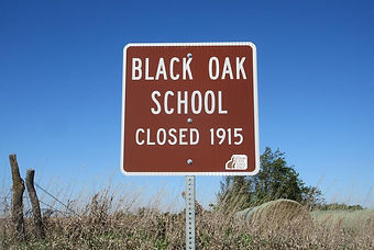
Black Oak School
Location: north side of Shaw Street and east of Hwy T-17 at Jct. 198th Place. (N 41°13.570', W 92° 53.967')
An abundance of trees once surrounded the many creeks that flow through Liberty township so it’s not surprising that one of its schools would be named for the Black Oak tree. Surnames of students who attended the school were King, Butterfield, Hauenstein, Davis, Rose, Allen, Cade, Ellis, Hart, Coop, Carter, Marshall, McGruder, Rhodes, and Simmons. The school was consolidated into the Attica district before 1920.

Black Swan Coal Mine
Location: N side of Coolidge St. 50 ft. West of Swan City limits. (N 41° 27.900', W 93° 18.956')
Initially called the Central Coal Mining Co, it was in operation from 1885 until 1897 or 1898.The coal camp was located across the main road into Swan from Hwy 316 and North of the cemetery. Many miners lived in Swan and the surrounding area.
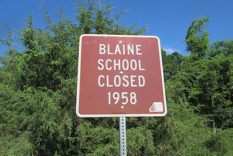
Blaine School
Location: West side of Jct. of Hayes Dr. and Hwy 14. (N 41° 23.556', W 93° 06.546')
Blaine School was named for Captain Blaine, farmer and Civil War veteran. In its early days, there was a singing school on Saturday evenings. On Sundays, a Baptist Church used the building for services and Seventh Day Adventists used it for classes. The school was once about five miles north of Knoxville on Hwy 14. After closing it was moved about a mile south and remodeled into a two-story house located at 1238 Illinois Dr.

Brownlee School
Location: At 1610 130th Place. (N 41° 17.491', W 93° 05.994')
This school stands on its original site. Whenever the creek below the school flooded, some parents were forced to take their children to Knoxville and return by another road in order to get to the school grounds. Closed 1954

Buckeye School
Location: Northeast corner of Jesup Dr. & 112 Ave. (N 41* 21.846’, W 93* 08.018)
Many country schools adopted the names of trees that were prevalent on or near the schoolyard. When I attended country school one of my teachers drilled holes in buckeyes so we could string them with wires to form a decorative wreath. After the school closed it was moved to a new location and made into a home. The earliest teachers found in newspaper records were R. C. Nace, 1886, Aletha Davenport, 1889, and Maggie Morrison and Flora Batten in 1895.

Bunker Hill School
Location: On 200th Ave. 1/2 mile north of Clemens St. (N 41° 28.758', W 92° 58.027')
In 1858 when Johannes Hendricks and Gertie sold an acre for $1.00 for the school it was known as District 68 because it was the 68th school to be established in Iowa. The name Bunker Hill was picked for its historical significance and the fact that it was on a hill overlooking the country. It closed in 1958.

Burch School (Union Township #5)
Location: On 92nd Avenue, ¼ mile north of Hoover St., 4 ½ miles east of Pleasantville., Union Township, T76 R20 Sec 16, e ½ of n.w. ¼.
Named after William Burch, a pioneer settler in this section. Also known as Hyer School., Nearby, on Hwy G40 is the pioneer Burch Cemetery, also named after this family. Like many country schools, heated by a coal-burning stove in the center of the floor.

Burr Oak School
Location: Jct. 94th Place and Perry St. (N 41° 16.840', W 93° 09.696')
In 1877 Gov. Stone came to address the students on “the issues of the day”. Former Collins Hospital Administrator, Helen Ward Roberts was hired to keep order in 1926. She held a pie supper to raise funds to buy curtains, a good teacher’s desk, and a four burner kerosene stove to prepare hot lunches. Closed 1946.

Caloma
Location: NW Jct. Perry St. and 20th Place. (N 41° 16.636', W 93° 18.559')
An old town that had its post office housed in the general merchandise store from 1858-1907. There was also a blacksmith shop, barbershop and a doctor’s office. In the 1870’s a hotel served as a stagecoach stop. In 1912 it had a population of 25.

Caloma School
Location: SW of Jct. of Pioneer St. and 20th Pl. (N 41° 15.961', W 93° 18.545')
A well can still be found on the school yard but the building disappeared years ago. The town of Caloma was nearby. Closed 1959.
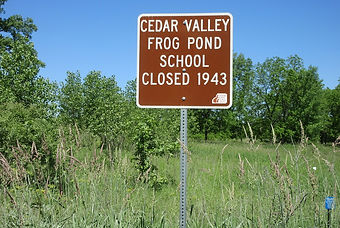
Cedar Valley (Frog Pond) School
Location: 3/4 miles south of Vernon Dr. on 168th Place. (N 41° 10.516', W 93°01.707')
The name relates to its location near Cedar Creek. Sometimes the creek flooded the road and the children had to walk through farm fields to get to school. Closed 1943.

Chicago School
Location: N.E. corner Hwy G76 and 20th Place, Bauer.
Chicago School operated as a public school taught by the Catholic Sisters who lived across the street in Bauer. This Catholic community was the home of St. Joseph's Catholic Church and St. Joseph's School. The school district opened in 1870 with a brand new building as noted in the Knoxville Journal.

Cincinnati School
Location: West side 140th Ave 400 ft. south of house #133 (1/4 miles south of Hwy 163). (N 41* 30.101’,W 93* 04.972’)
This school bordered on the Jasper county line. There were always fewer students attending this school than most Marion county schools. This probably explains why it closed earlier than most in the spring of 1934. Early records primarily record students with Dutch names such as Monsma, Vander Ploeg and Vriezelaar.

Clark School (Union Township #6)
Location: Across from 798 Hwy G40, the Bensink Game Farm, 3 ½ miles east of Pleasantville. Union Township, T76 R20 Sec 18 s.e. ¼ of n.e. ¼.
Like many country schools, teachers boarded with a nearby family.
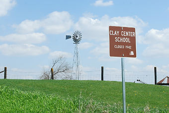
Clay Center School
Location: NE of the Jct. of 215th Ave. & Old Hwy 92. (N 41° 17.883', W 92° 56.274')
The name implies that it was in the center of Clay township. Maybe not. The Des Moines river makes a diagonal cut through Marion county making it difficult to divide townships into tidy rectangles or squares. The school house sat on a farmyard between a house and barn. it closed in 1942 when only two students were left. They recall they did all their work in the morning and played Rook in the afternoon.

Clay Township Fairgrounds
Location: East side of 224th Place, 1/2 mile south of Old Hwy 92, 100 yds. north of Creek Bridge. (N 41° 17.169', W 92° 55.348')
Location: East side of 224th Place, 1/2 mile south of Old Hwy 92, 100 yds. north of Creek Bridge. (N 41° 17.169', W 92° 55.348') The Clay Township Agricultural Society held fairs from 1855 to 1892 at the Old Camp Meeting Ground, 1 1/2 miles NW of Bethel. Classes offered ranged from livestock to baked goods and everything in between (much the same as today), with premiums from $2.00 for the first place stallion to 15 cents for second place potatoes. Permanent structures were erected and a spring located at the site provided an ample supply of water. No games of chance in any form were permitted at the fairgrounds. The gate fee was 15 cents for anyone over 10 years of age and 5 cents for each horse not entered for a premium.

Cloud Post Office
Location: On South side of Virginia St. just West of Railroad. (N 41° 10.483', W 93° 14.172')
1888-1906: Named after the Cloud family. In 1901 Sarah Cloud owned the property. Although Cloud was never formally laid out as a town, it grew into a center for local farmers.The Marion School was located west of the community.

Coal Ridge School (Indiana Township)
Location: On East side of 186th Place at House No. 2418 (N 41* 10.496 ’, W 92 *59.488’)
This school was organized in 1861 and closed in 1946. It is often confused with a different Coal Ridge School which was near the Coal Ridge Church. There were so many coal ridges in Marion County that it is no surprise that two were given the same name.

Collins School
Location: 121 25th Place, west side of road (a quarter mile south of the Jasper County line). (N 41° 30.264', W 93° 08.070')
In the northwest corner of Marion County, the school district was bordered by Polk County on the west and Jasper County on the north. The first building was a log cabin. It was replaced by a frame building which burned down. The final school was also a frame building with a bell tower. One of its many teachers was Nanie Hyatt who died at 71 years, the same year she retired after teaching for 51 years.

Columbia School
Location: South side of Virginia St. E. of Jct. with 103rd Ave. (N 41° 10.522', W 93° 09.011')
Named for earliest settlers who came from Columbia, Ky. In 1871 a two room school replaced an older structure. When the school burned in 1933, it was replaced with a one room structure. In 1966 it was one of the last rural schools to be closed.

Concord Methodist Church
Location: East side of 130th Place just south of Jct with Quebec St. (N 41* 14.862’ , W 93* 06.534’)
Concord Sunday School was organized on April 29, 1855. Church services and Sunday School were held in neighborhood homes until a church was built in 1862. Walnut seats were made from trees taken from Socrates K. Bellamy's walnut grove. Services were not held in the winter of the early years due to bad weather and bad roads. Attendance varied between 57 to 104. In 1887 second-hand organ was purchased for $25 and a Saturday night singing school was organized. An Ice Cream Festival was held in June,1889. The church was first lighted with coal oil lamps hung from the ceiling, then carbide lights, and finally with electricity. Heating progressed from coal stoves, to a coal furnace, to an oil burner, and finally a gas furnace. The 100-year centennial was held on October 21, 1962. An article on the church's history was written for the occasion by Mrs. Robert (Helen) Stevenson and Hazel Craig which appeared in the Knoxville Express, October 18, 1962. A photo of the church was also printed for this article. A photo of the Sunday School class, about 1914, appeared February 27, 1985, in the Knoxville Journal or Express. In 1983 the church furniture was moved to Evelyn Beebout's barn and $91 was paid to the Des Moines District's abandoned church fund. This included 9 pews for $72, a pulpit, $5, and 2 chairs, $10. The Iowa Conference of the United Methodist Church in Des Moines deeded the church property to Lee & Myreeta Rowland on June 6, 1984, who bought the property for $250.

Consolidated Indiana Coal Co. #1
Location: East side 60th Ave. and lane to house #2200. (N 41° 12.259', W 93° 13.916')
This mine was worked from 1912 to 1922. The shaft was 185 deep and extracted coal from 3 to 6 and 1/2 ft. thick.The camp was called Electra because it was the first mine in Marion County to be completely operated by electricity as well as lighting the houses.

Consolidated Indiana Coal Co. #2
Location: north side of 216 Pl., west of house #1072. (N 41° 21.986', W 98° 57.476')
Located approximately one mile west of the Melcher-Dallas line. This good producing mine along with #1 and the Red Rock Mine were all owned by the Rock Island Railroad.

Crooked Road
Locations: Newbold St. and Nixon St. East end (N 41° 17.938' W 93° 07.702'), Jct. 60th Ave. and Rutledge St. West end. (N 41° 14.019', W 93° 13.930')
Once a state route from Knoxville to Dallas this is indeed a crooked road with 22 turns. In the early days of settlement, roads often followed ridges and avoided slicing through homesteading claims, creating many twists and turns. Unlike many such roads, this one was never straightened. There are 12 signs marking the route from east to west.

Dallas Center School
Location: Northwest corner of Jct of Tyler Street & 40th Place (N 41* 12.280’, W 93* 16.252’)
A former student says this school was sometimes confused with the town of Dallas Center. Here is the list of teachers that was left out of One Room Fit All, the Country Schools of Marion County, IA Teachers were J. W. Elder 1879; R. J. Mood 1891; A.T. Peas 1886; W. H. Miller 1891-92; Miss Roberts, Mr. F. Crew 1893; Eva Gardner 1895; Viola Goering 1896; Frany Kebiddle 1899; Anna Hiller 1900; Mattie Gray 1903; Elsie Mason 1904; Mattie Gray, Emma Smith 1905; Mrytle E. Smith, Olive Hunnerdosse 1906; Mrs. Anna Bones 1907; Emma Smith 1908; Clara L. Mason 1909; Char. Leavengood, Clara Mason 1910; Laura Mason, Clara Mason 1911; Rachel Wilson, Clara Mason 1912; Elizabeth Herschauer 1913; Rhea Dark, Nellie Neuman 1914; Alice Murphy 1915-17; Lois Bachman 1919; Loraine Todd, Nora Miller 1920; Nora Miller 1921; Lucille Weishaar 1922; Ruth Linscott, Mrs. Thelma Fletcher 1924; Mary W. McCombs 1925-26; Joy Harkin 1927-28; Marie Carter 1930; Elsie Frobasu Stallings, Marie Carter 1931; Paul J. Waddle 1932-34; Nellie Caffery 1936-37; Nellie Caffery Wadle 1938; James H. Bauer 1939; Geneva Bauer 1940-41; Maxine Bell 1942; Elizabeth England 1943; Mrs. Elizabeth Lillard 1944; Miss Rose Marie Estes 1945; Esther Brown 1947; Betty Lou Boyd 1948; Esther Brown Bourek 1949; Mrs. Luree Straup 1950; Mrs. Hazel Perry 1951-55; and Iantha Bucklew 1956-58.

Donley Station
Location: On outside of curve on 82nd Ave. Sec. 32-76-20. (N 41° 20.625', W 93° 11.467')
1875-1965. This was a shipping point on the Chicago, Burlington and Quincy serving the needs of those in the western half of the county. A small community grew up around this once busy place. It was named for land owner Oliver Donley who owned 900 acres . The railroad time tables listed ‘Donnelly’ as the spelling.
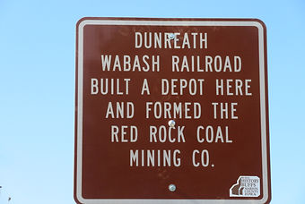
Dunreath
Location: Red Rock Township 77 Range 20 Section 21, south end of 90th Place.
Dunreath's population was 435 in 1890. It owed much of its success to the Wabash Railroad. The original plat was recorded as having 228 regular lots. The town's structures were razed when Lake Red Rock was formed.

Durham
Location: West of Hwy. T-17 and North of McKimber St. (N 41° 19.216', W 92° 57.331')
This old town was laid out as a station on the Chicago, Burlington, and Quincy Railroad in 1875. Originally called Merrill, in 1877 it was renamed Durham in honor of early settler David Durham. The town once had a hotel, post office, blacksmith shop, creamery, doctor’s office, two general stores and a school. In 1912 it had a population of 100.
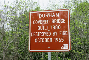
East Durham Bridge
Location: Highway T17, west edge of Section 4 Clay Township, just south of Eureka Cemetery
This bridge crosses English Creek and for decades it was popular spot for teenagers to gather on weekend nights. On Saturday night, Oct. 2, 1965 it was destroyed by an arson fire. About 10 years earlier the county had refreshed the bridge placing four 18-inch-I -beams under the floor of the 55 foot span. At the time of the fire it was one of four covered bridges standing in Marion County.

Elevator Road
Locations: South of Jct. T-17 and Hwy 16; North of Jct. T-17 and Keokuk Dr. (N 41° 23.206', W 92° 54.852')
A familiar name to area residents. As a little girl one of them thought it was so named because of its steep hills that went up and down like an elevator. It’s actually a reference to the grain elevators on the south end of Pella.

Elm Grove School
Location: NE of Jct. G-76 and 120th Ave. (N 41° 12.268', W 93° 07.087')
Like other war time teachers Lois Atkins remembers having to register district families for ration books. As a teacher with 30 years experience teaching in a town school, she still feels country schools provided a better education experience. Closed 1959.
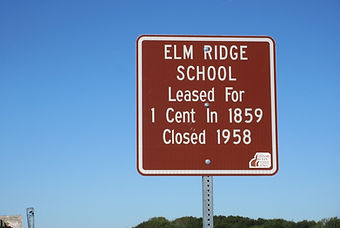
Elm Ridge School
Location: West side of Lisbon Dr. at House #1524 (N 41* 19,470’, W 93* 03.178’)
In 1859 the land was leased for one cent from Joseph Frank for this school which closed in 1958. Because it was close to Knoxville, the school was mentioned often in the Knoxville Journal. The paper recorded that the first building was made of logs and had an old fashioned fireplace. There were two windows and no desks, only rough slab benches with no backs. In the spring of 1912, a fire destroyed a new building built only 20 years earlier. All the books were lost including a set of encyclopedias (valued at $21) and owned by the teacher.The term was finished in the Flagler chapel.

Empire School (aka Buzzard School)
Location: East side 61st place at Jct with Pratt Street (N 41* 15.535’, W 93* 13.684’)
Since there has been no deed found for this school its opening date is uncertain. Like other schools, it was the center for community entertainment. In May 1892, The Knoxville Journal announces there will be a stereopticon entertainment on Thursday evening; stereopticon was the forerunner of the movie. In 1892 there were 32 students, but by 1917 the school had closed. Can one assume that it derives its name from a flock of turkey vultures that roosted nearby?

Englewood Christian Church
Location: n.e. corner of Quaker Dr. & 115th Place, about 4 miles southwest of Knoxville. Knoxville Township, Twp 75 R 20 Sec 35, n.w. ¼ of s.e. ¼.
Moved in 1946 to 102 W. Washington St., Knoxville. Remodeled into a house which has a large window facing 3rd Street with arched glass above the window similar to what you would see in a church.

English Creek Coal Co.
Location: East side G-44 and 0.35 mile North of Pleasant St. (N 41° 19.570', W 93° 03.758')
This mine which was first known as the Hawkeye Coal Co. operated from 1896 to 1912. There three mines between Flagler and the 3M plant. Wade Phillips of Phillips 66 fame helped his brother manage the mines.
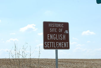
English Settlement
Location: SE of Jct. 195th Place and old Hwy #92. (N 41° 18.153', W 92° 58.601')
An early settlement that extended on both sides of English Creek, it had a post office from 1850-1878. G.G. Harsin, and D. T. and F. T. Durham were among its earliest settlers. It was considered to be one of the most reputable neighborhoods in the early days.

Eureka School
Location: SE corner of Jct. of Hwy T-17 Lowe Dr. (N 41° 19.868', W 92° 56.865')
The first school was a sturdy brick building constructed shortly after the Civil War. When the school closed in 1958, its frame building was used as a community center before being moved to Knoxville in 1961 and remodeled into a home. The flagpole was moved to the Eureka Cemetery. A covered bridge over the creek just beyond the cemetery was a favorite gathering place for students.
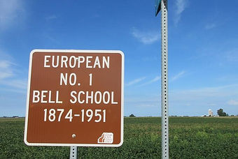
European # 1 (the Bell) School
Location: West side of Hwy. T-14 at Jct. with Dakota Dr. (N 41° 27.707', W 92° 55.255')
The district was thought to be organized around 1854. Built in 1870 , the school stood in place until it was torn down in 1960. The bell hangs in the belfry of the replica of the Scholte Church at the Pella Historical Village.

European # 3 School
Location: On North side 218th Pl 1/8 mile West of Jct. with 240th Pl. (N 41° 27.048', W 92° 53.828')
It was sometimes called the Mathes School because its first 16 by 20 ft. building was on ground owned by the Mathes family. After the school closed in 1958 the school building was moved to the Elevator Rd (228th Ave) and remodeled into a home.

Everist
Location: West side of Hwy. 5 at house #2167. (N 41° 12.602', W 92° 57.681')
1915-1935: Everist, the center of a coal mining district, grew up around a spur of the Wabash railroad near Cedar Creek. Its population in 1914 was 300. Its principal business enterprise was a large general store operated by the Everist Mercantile Company.

Fair Oaks School
Location: East side 140th Ave., East side of 140th Ave., 1/2 miles south of Dubuque Dr., (N 41* 26.408’, W 93* 04.942’)
Fair Oaks was on property owned by Delos Vanden Berg.For many years it was where the children of the Dutch farmers in the surrounding area received their grade school education. It’s best known teacher was Grace Cronkhite Karr who began her teaching career at this school after graduating from Knoxville High School in 1919. For many years she wrote a folksy column called The Cordova News.

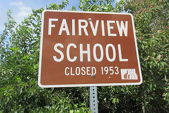
Fairview School (Clay Twp.)
Location: 500 ft. south of #1667 Hwy. T-17 on west side. (N 41° 23.112', W 93° 05.500')
It stands on its original site and is being used for hay storage. Fairview closed in the early 1950’s and then reopened because nearby McMillan had become too crowded. It closed for the last time in 1958.

Fairview School (Dallas Twp)
Location: North side Virginia St., 1/4 mile east of 20th Place (N 41* 10.510’,W 93* 17.664’)
According to Robert Gruebel who graduated from high school in 1951, there were 12 to 15 students who attended there when he did. Teacher Alica Shore stayed with his family during the winter months and they walked together across the fields to get to school, The students called themselves the Fairview Cardinals and published a monthly newsletter called the Cardinal Chatterbox. If anyone runs across any copies of this newsletter please donate them to the Marion County Historical Society for their country school archives.

Fairview School (Franklin Twp.)
Location: On McKimber St., ¼ mile west of the Fairview Christian Church, 5 miles south of Pleasantville off Hwy S45. T75 R21 Sec 3, s.w. ¼ of s.w. ¼.
One of 6 Fairview Schools in Marion County. Consolidated into Pleasantville Schools in 1940. A WPA (Works Progress Administration) project in the 1930s was to build new outhouses here. The site now is a timbered, brushy oasis in a sea of cropland.
Fairview School (Polk Twp.)
Location: 135th Ave one mile south of Hayes Dr. (N 41° 16.885', W 92° 57.420')
Located in Polk Township, it was one of six by that name in the county. It is standing on its original site. In 1922 there must have been a “fair view” from every window as there were 55 trees on the school yard. Closed 1952.

Fairview School (Red Rock Twp)
Location: Northwest corner Jct. Beardsley St and 85th Ave. (N 41* 29.662', W 93* 11.272')
This school was so far north that it had a Monroe address. A picture from 1907 shows students with familiar neighborhood names: Waddle, Nimmo, Templeton, Kool, Kingery, and Simbro. Their teacher was Sadie Mulllins. She also taught in 1903, 1906, 1921 and 1922. It was unusual for a teacher to teach intermittently like she did.
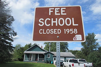
Fee School
Location: At #1349 on 118th Place. (N 41° 19.687', W 93° 07.626')
This school which is on its original site was remodeled into a home in 1958. It was once equipped with an underground storm cellar in case of a tornado. An 1877 Journal reported "The last day of school was the place to go for a square meal with 50 bringing food to satisfy the cravings of the inner man, chicken, pies, and cakes from the home larder."
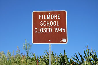
Filmore School
Location: West side 94th Place 1/2 mile south of Rutledge St. (N 41*13.588’, W 93* 09.970’)
This school was probably named for our 13th President Millard Filmore who served between 1850 and 1853. He came from a large family and had little formal education so he studied on his own. He was the first president to have a library in the Whitehouse. Bev Jones has pleasant memories of the only year she attended school there before it closed. Her teacher Ruth Kinney invited her and two other little girls to bring their dolls with furniture to her house for an overnight stay. Many of the teachers found unique ways to form a relationship with their students.

Flagler School
Location: East side of T-15, 50 feet north of RR overpass. (N 41° 19.669', W 93° 01.468')
In 1875 when the C.B. & Q. Railroad reached Flagler, thanks largely to the abundance of coal. the little settlement became a boom town. It required the building of a larger three room school. The number of school aged children grew from 249 in 1887 to 304 in 1888. The school closed in 1961.

Flying Farmers of IA Metcalf Airstrip
Location: South side T-15, 150 ‘ East of house #1828. (N 41° 20.532', W 92° 59.984')
1955-75. "The Flying Farmers" were a group of early days farmers (1940+) who got the itch to fly. Most of them acquired a 2-seated Piper Cub plane and made a grass landing strip on their own farm. That was what Stanton Metcalf did. The building where he kept his plane is still there.

Franklin Center School
Location: 403 Newbold Street. (N 41° 17.928', W 93° 16.307')
As in many schoolyards, there was a shed for the ponies that students rode to school. One day when a windstorm came up, the roof was blown off the shed. Later the ponies were found, still tied up and standing on the shed roof. Former student Darrell Gifford has contributed several stories about his experiences here. Find them in a binder at the museum in the Marion County Park. Closed 1955.

Freedom School
Location: East side 60th Ave on North side private lane 1/2 mile South of G-76. (N 41° 12.273', W 93° 13.910')
Sometimes called Electra, the school started as a one room school but when mining came to the area it was enlarged to three rooms with 100 students enrolled. After the mine closed it became a rural school for a few farm children with the original room being used for storage, one new room for class and the other new room for a playroom. Closed 1944.

Georgia Ridge School
Location: South side of Jewel St. 0.35 West of 102nd Ave. (N 41° 21.619', W 93° 09.592')
Mrs. Ruth Kenney was the teacher when the school closed in the spring of 1956. A newspaper article in the Knoxville Journal indicates that it was in existence by at least 1859, indicating that it probably served the neighborhood children for nearly 100 years. The first recorded teacher, however, was George Smith in 1879.

Germantown
Locations: West side 20th Place South of Rutledge St. (N 41° 14.015', W 93° 18.559'); East side 20th Place South of Rutledge St. (N 41° 13.902', W 93° 18.556')
This was a small settlement composed primarily of German immigrants.This is also the location of St. Paul’s Evangelical Church with a cemetery to the north. Horstman School, sometimes called Germantown School, was built on land owned by the Horstman family. They donated the land for the church in 1872.

Gosport School
Location: South side of G-76 400 ft. East. of 103rd Ave. (N 41° 12.274', W 93° 09.053')
Several newspaper articles from the early days scold this school with not paying teachers enough for the many students attending. In 1879, for example, J. W. Collins was paid $18 per month to teach 60 students. Three or four were crowded into desks designed for two. As of 2010 former students were still holding an annual reunion. Closed 1963.
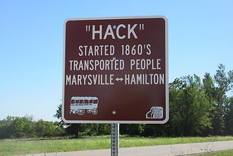
Hack (stops) transporting people between Marysville and Hamilton
Locations: SW corner Depot St. & Wabash Dr. (T-23) in Hamilton (N 41° 10.292', W 92° 54.157'); NE of Jct. of Oak St (Virginia Dr.) and Mill St. in Marysville. (N 41° 10.929', W 92° 57.242')
A hack was the early equivalent of a public taxi service. Besides passengers, the vehicle might carry mail or freight. it was a convenient way to leave horse and buggy at home and ride from your small town to the nearest railway station.

Hammond Covered Bridge
Location: On 170th Place over North Cedar Creek. (N 41, ° 10.698', W 93° 00.855')
Built in 1894 and named after landowner Samuel B. Hammond (1861-1938) who wanted the bridge built. It is a Howe truss structure 78 ft. long set on concrete-filled iron cylinder piers. Listed on National Register of Historic Places in 1998. Rehabilitated in 2003 by Herberger Construction Co. at a cost of $178,195. The creek now runs under the 100 ft. approach on the the north side. A concrete ford just downstream carries vehicular traffic. More info at http://fhwa.dot.gov/BRIDGE/hammondbridge.htm

Harvey Peace Tree
Location: 501 Wabash St., east side of Harvey
The sign is by a sycamore tree over 100 years old, the last remnant of Dr. Barker’s arboretum. The sycamore was chosen for this honor due to its white trunk and limbs which symbolize peace.
Barker asked the U.S. War Dept. in the 1920s to plant sycamores in every one of the 84 National Cemeteries to honor veterans there. His arboretum in Harvey was a tourist attraction in the 1930s which also invited school groups to visit.

Harvey Railroad Bridge
Location: About 1/2 mile East of Harvey on Depot St. NE of Jct. with 228th Pl. (N 41° 18.984', W 92° 54.790')
Before becoming a railroad bridge it was the site of a ferry and a temporary bridge. Built in 1878, it consisted of four pinned Pratt through trusses which were supported by stone abutments and piers. The bridge was 600 ft. long and 12.8 ft. wide. It carried railroad traffic until 1938. It is still in excellent condition and can be crossed to get to “the island.”

Harvey School
Location: On the west side of old school in Harvey
The brick school was built in 1902 at a cost of $5000. This was a country school whose official name was the Des Moines Valley School. For a time it served all levels of grade and high school with the first high school class graduating in 1924 and its last class graduating in 1946. It continued as a grade school until the spring of 1962. It is currently a historical museum.
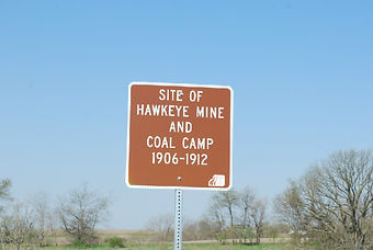
Hawkeye Mine and Coal Camp
Location: West side of Lucas Dr. 700 ft., north of Mckimber Drive. (N 41° 19.399', W 93° 02.594')
The mine began production in 1900 and lasted until 1915. The underground mine was totally to the south side of old Hwy. 92 (now T-15) It was sold to the English Creek Coal Co. in 1905. The main camp was located on a large three cornered piece of land between the Rock Island Railroad and the old Pella road. A railroad spur from the CB & Q connected to the Rock Island enabling them to ship coal on both rails.

Hazel Ridge School
Location: South side of Perry Drive , 1 mile west of S-45 N 41* 16.845’, W 93* 15.981
Once called Gospel Ridge, the name was changed to Hazel Ridge in 1908. The school closed in 1936, probably due to lack of students. Earlier in 1885, it had 30 students.

Hickory Grove School
Location: 1100 block Beardsley St., ½ mile south of Jasper County line. Red Rock Township, T77 R 20 Sec 2 n.w. cor of s.e. ¼
Closed in 1920 due to its close proximity to Monroe. The school district remained in the County Superintendent’s reports, marked closed, until 1947 when the building was sold and moved to 402 S. Commerce St. in Monroe, where it was remodeled into a house.

Highland School
Location: SW junction of Nimrick St. & 70th Ave. (N 41° 17.701', W 93° 12.827')
This school district served students in both Franklin and Knoxville townships. In 1917 after a log building burned down, it was replaced with a building of tile blocks covered with stucco. One former student declared the best asparagus she ever ate was prepared by her teacher from asparagus growing on the school grounds. Another student recalled a happy memory of his teacher taking 7th and 8th grade students on a train ride to Chicago. Closed 1957.

Horn’s Ferry
Location: Both sides of the Des Moines River on 198th Place. (N 41° 21.699', W 92° 58.162')
Operated from 1865 to 1881 when it was replaced by the Horn’s Ferry Bridge in 1882. This bridge was one of the county’s first river crossings and the first wagon bridge over the Des Moines River. A section of the bridge collapsed on the night of Aug. 1,1992. There are observation points on both sides of the river.

Horstman School
Location: East side 20th Place, south of St. Paul Lutheran Church (N 41* 13.827, W 93* 18.556’)
Deeded in 1868 and closed in 1956 this school was near the settlement of Germantown. Fern Welch Jones who taught there in 1925-26 said that teachers usually boarded with someone in the school district for about $20 per month when salaries were $40 and up. During her career Fern’s lowest salary was $70 and her highest was $140 per month. In the early days, there were three terms each year. Fall three months, winter three months, and spring three months (this would require much adjustment for both teachers and students if a district hired different teachers for each term).

Howell
Location: On NE corner of Jct. of 216th Pl and 198th Pl. (N 41° 22.172', W 92° 57.763')
Howell was laid out in 1882 for the Union Coal Co. as a station for the Wabash railroad. Six trains passed through daily hauling away great quantities of grain, coal, and livestock. The depot was always referred to as Howell Station. The Pella Municipal water pumping plant is located slightly to the north of the depot which was torn down in 1932.

Iola Post Office
Location: South side of G4-6 about 900 ft. East of 195th Place. (N 41° 20.531', W 92° 58.439')
In 1854 Joseph Clark was appointed as the first Postmaster. D. T. Durham was appointed in 1856 and at the time Wm. M. Donnell published Pioneers Of Marion County in 1872, Mr. Durham was still serving as postmaster. The Iola Post Office closed in 1881.

Iola School
Location: South side of G4-6 about 900 ft. East of 195th Place. (N 41° 20.531', W 92° 58.439')
The school was organized in 1863 and built on land donated by D. T. Durham. Old records before 1900 indicate that teachers were monitored closely as one was charged with inflicting “cruel and unusual treatment” and for his neglect to give blackboard exercises in arithmetic for a period of six weeks. He resigned before being brought to trial. Closed 1956.

Iowa’s Largest Open Pit Coal Mine, Sinclair and Wilkinson Coal Co. 1949-1963
Location: On the east side of T-17 approximately one mile north of Hwy 5. (N 41° 14.309', W 92° 57.081')
When demand for coal began to dwindle due to conversion of railroads to diesel fuel, this mining company from Oklahoma moved its workers to Marion county. Several local miners were also employed in this and other nearby pit mines run by the company. In some places the workers were digging for coal over abandoned underground mines. Major customers included Iowa Power and Light, Des Moines; Iowa Southern Utilities, Eddyville; John Morrell, Ottumwa and Iowa State College, Ames.

Johnny Cake Road
Locations: East of Jct. Hwy. 5 and Utah Dr. (N 41° 11.091', W 92° 55.855'); West of Jct. T-23 and Utah Dr. (N 41° 11.404', W 92° 53.587')
It was just a narrow and hilly lover’s lane until Bobbie Kocur called attention to it by writing and recording the song “Johnny Cake Road”. Johnny cakes made with cornmeal were a common food of the pioneers. Why the food is associated with this road is a mystery.

Kimball Livestock Yards
Location: 60 feet North of Railroad on West and East sides of 30th Place. (N 41° 20.734', W 93° 17.446') (N 41° 20.721', W 93° 17.463')
Like many other communities the Kimball stockyards was the place where local farmers drove their livestock to be purchased by the manager. They were then resold to other farmers who wanted to increase their breeding stock or to locations further away for meat processing.

Kimball Social Circle Building
Location: 1273 -25th Place ( N 41* 20.340’ , W 93* 18.303’)
The Kimball Community dwindled in the 1940's due to the increased use of automobiles, residents moving away, and the closure of Kimball's stores and depot. During the WWII years, the Kimball Social Club building was used for combined social events for the remaining Kimball neighborhood and Pleasantville. Even though dancing had been prohibited by the original by-laws of the Kimball Social Club, many dances with live music were held there providing much appreciated entertainment for a war-weary population. In 1950, the building and land was purchased by Hoot and Betty Richards for one dollar and dragged by horsepower to the family farm a few miles west where it was converted into a home. They lived there for 52 years and raised three children in the old community center. In 2017 the house sustained significant damage by a tornado.

Kimball Social Club Building
Location: 1273 25th Place, southwest of Pleasantville
This sign is on the same post as a previous sign of that name. It is the 4th sign to mark the ghost town of Kimball which also has signs on 30th Place.

Kimball- site of old town
Location: Approx 900’ feet South of Railroad on East side of 30th Place (N 41° 20.645', W 93° 17.436')
The town sprang into existence with the arrival of the railroad in 1912. It had a depot (actually a box car), a grain elevator, a blacksmith shop, two stores, a community building, and a school. In 1915 the ladies of the community organized a social club which served many functions including aiding the Red Cross during WWI. With the coming of the automobile, the town, including its social club, gradually disappeared.

Liberty Corner School
Location: NW corner of Jct of Carpenter St. & 120th Ave. (N 41* 28.776’, W 93* 07.237’)
Liberty Corner was often confused with another school named Liberty in Summit twp. That school located near Otley was often called Liberty Corner and is still standing. This school is not. The earliest recorded teacher was in 1875 and it is likely that the school existed earlier. It closed in the spring of 1938.
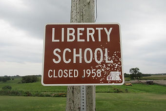
Liberty School
Location: South side Jct. of Oregon Dr. and 165th Ave. (N 41° 17.077', W 93° 01.998)
Located in Knoxville Township, it served the children of many coal mining and farm families in the area. In the 1920’s it had a very large school age population necessitating the building of a two room structure. The earliest record of teachers dates back to 1868. Closed 1958.
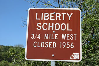
Liberty School
Location: at junction of Virginia St. and 78th Ave. (N 141+ 10.511 W 83+ 11.961)
Evidently whoever named this school had an interest in honoring U.S. history. The earliest teacher named in the Knoxville Journal was Dr. Kirk who taught in 1877. The last teacher was Luella Beebout, a familiar name in the area. This school sat on the township line with one half of the district in Washington township and the other half in Dallas township.

Lincoln School
Location: NE Jct. 92 Ave. and McKimber St. (N 41° 19.322', W 93° 10.595')
The building is in its original location and has been converted into a home. In 1877 there were 63 students. Early school boards preferred to hire men teachers whenever there were large numbers of students as they felt a man’s size gave him an edge in maintaining discipline. Closed 1958.

Long Lane Road
Location: South side G-76 East of Hwy. 14 (N 41° 12.274', W 93° 08.446'); North side G-76 West of Van Buren Dr. (N 41° 12.260', W 93° 01.586')
According to local lore in the horse and buggy days it resembled a dirt lane that stretched forever, thus a long lane. Actual distance is six miles.

Mammoth Vein Coal Co. # 5
Location: South side G-71 at house # 2062. (N 41° 13.138', W 92° 57.267')
It was one of several mines in the areal also known as OK Coal Co. and Empire Coal Co. The main shaft was put down into 14 ft. of coal. In 1906 there were 400 men employed in this mine which lasted from 1900 until 1938.

Maple Grove School
Location: NW Jct. Newbold St. and 110th Ave. (N 41° 17.923', W 93° 08.261')
It started in a log cabin in 1860. A former Knoxville Principal, J. R. Young, began his teaching career as a country school teacher at this school. Closed 1950.

Marigold Springs
Location: East side of 115th Place 0.4 mile North of G-40 at House #820. (N 4, 1° 24.316', W 93° 07.750')
“A good time was had by all.” From 1920 to 1943 this was the location of a swimming hole formed by damming up a spring or springs. Families used the pool in the daytime but a different younger crowd gathered at night. It is said there was both drinking and dancing. Watchful parents warned their daughters never to be there at night.
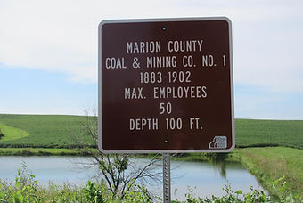
Marion County Coal and Mining Co. #1
Location: On Dubuque St. near house # 1591. (N 41° 27, .039', W 93° 02.638')
Open from 1883 to 1902, it was operated by steam power. Its shaft was about 100 ft. deep. The coal was hauled by CRI & PRR on a spur that came from the east side of Otley.

Marion School
Location: North side Virginia St, 1000 ft. west of 50th Place (N 41* 10.518’, W 93 * 15.236’)
Neither the date of opening nor the deed has been found for this school. The closure date was 1956. A schoolhouse burned in 1894. Its replacement was saved from burning in 1941 when a call to the Melcher/Dallas fire department quickly put out the sparks on the roof. When Winifred Hyatt started to school in 1920 she walked with a neighbor girl carrying a Big Chief tablet, a new box of crayons, a collapsible tin cup, a pencil box, and a lunch pail. All the essentials to begin one’s education.

McMillan Country School-Victory School District
Location: SE of 195th Place & Old Hwy 92. (N 41° 18.153', W 92° 58.601')
This school has an unusual history. According to the official records it was once divided into two districts, known as North and South McMillan for a period of about ten years, but no one can recall whether the familiar building was the North or the South one. It was moved from its original location and in its final years was known as Victory Central because students from other schools that were closing down began attending there.

Mineral Artesian Well
Location: Near 1721 Cronwell St, Flagler.
This dead end street is currently spelled Cronwell, although the original plat and early families spelled their name Conwell. Both Knoxville newspapers featured this well in their October 10, 1935, editions.
The well was dug in 1880 to a 700 foot depth and lined with sandstone. It was jointly owned by two coal companies and several other residents. Many barrels of “Flagler Mineral Water” were shipped by rail all over the United States and overseas. The water was considered a remedy for all ailments and its supply was dependable, even through the droughts in the 1930s. As the coal mines had declined, this mineral well kept Flagler pride alive.

Mount Olive Church
Location: NW Corner of Jct. of 92nd Ave. and Perry St. (N 41° 16.854', W 93° 10.311')
It was built in 1893 by a local contractor and people in the community. It was dedicated by Dr. Mill from Iowa City, assisted by Rev. Vorhees of Dallas. A reed organ and choir provided music. The pastor was often shared with the Dallas church. The church was closed in 1928 with members going to the Dallas Methodist Church. A Sunday school was started in 1932 for the local children but the church was closed again after a few years. In the summer of 1952, pastors from Dallas, Melcher and Knoxville led activities at Mt. Olive, but in the late 1950s it was torn down and the lumber used to remodel a home in Dallas.
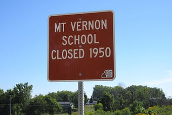
Mt. Vernon School
Location: East side 150th Ave. across from house # 1003 (N 41* 21.849, W 93 * 03.760’)
The flagpole still stands on the school yard on land that was donated bythe Holmes family. The late Jerry Graham started country school here andwrote a story about his experiences in his first year before moving to adifferent school district. One of things he remembers is the sandwichesmade of home made bread. It was always buttered bread and was sometimesfilled with home canned chicken, pork or beef or maybe a slice of cheese ora fired egg. Visit the country school archives at the Marion County Historical Society to read a detailed account of his first year experiencesat a country school.
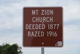
Mt. Zion Church
Location : West side 60th Ave, 200 ft. north of G-76 (N 41* 12.733’, W 93*13.924’)
Mt. Zion Church was deeded in 1877 and razed in 1916. A copy of the deed shows that one acre of ground was purchased by the Evangelical Association for $25 from Samuel and Sarah Strahau. This church was organized by Rev. Joseph Haut. He also organized the Methodist Church along with others including the Attica Church. A Feb. 24, 1916, Knoxville Express story reports the old church near the railroad crossing a mile south of town and which has been a landmark for years is rapidly disappearing as the lumber is being hauled to be used in the erection of a Methodist Church.
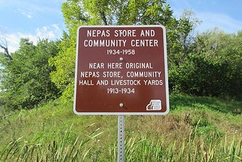
Nepas Store and Community Center
Location: SW corner of Perry and S-45. (N 41° 16.842', W 93° 14.864')
When the Rock Island Railroad came through in 1913 a livestock yard opened and the original Nepas Store was built along the tracks. It was a two-story building with a community center on the 2d floor. Nepas celebrated its grand opening with frog legs shipped by rail from Des Moines. In 1924 a Nepas celebration featured a guest speaker, bronco rides-“bring your bad horses”-picnic, greased pig contest, and a dance. In 1932 Hwy 181 was built a mile away. The original Nepas store was moved in 1934 to Perry St. and Hwy 181 where it continued until 1958 with Jeff Alton as the last store keeper. Besides groceries, it provided gas station/tire repair, and a community center for voting, school programs, parties and square dancing. Wow—let’s go to Nepas!

New Albany School
Location: East side Hwy. 14 at house #2028. (N 41° 13.827', W 93° 08.255')
Former student Rose Marie Briggs expressed the feelings of many who attended country school with the words: “ Country school was like being in a field trip every day, out in the country enjoying nature and fresh air. I thank God every day for the opportunity I had to enjoy country school and for the wonderful teachers who worked so very hard for all of us and especially for the valuable lessons learned.” Closed 1954.

New Chicago - Site of Old Town
Location: On Story Street east of of 20th Ave. (N 41° 13.143', W 93° 18.264')
1867-1881. New Chicago laid out in 1867 was on a bluff overlooking a creek. That same year Christopher Anderly opened a store. In a jocular spirit he gave the place the name New Chicago. The 1875 atlas shows five locations for dwellings. The post office which was opened in 1867 was closed in 1881 and moved one mile south to Bauer.
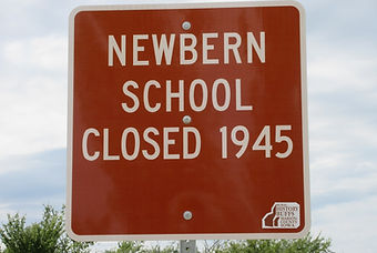
Newbern School
Location: West side N-S St., one block west of 2485 20th Place (N 41* 09.762’, W 93* 18.645’)
The school was in this location as early 1872 but no deed was found for it. The schoolhouse burned down in November of 1904. The replacement schoolhouse was moved to 2056 80th Ave. Having been recently repainted it looks much like it did when used as a school. During the depression years, it was impossible for some children to go on to high school when they finished the 8th grade, so they returned to Newbern, rather than drop out of school.

North Flagler School, originally Sumpter
Location: 1782 Hwy T-15, south side, 1/4th mile east of Hwy 14 (N 41* 20.533’, W 93* 00.580’)
This school was deeded in 1865 and closed in 1958. The name was probably changed to North Flagler around 1900. Students Stan Metcalf and Lawrence and Bill Van Zante showed an early interest in creating things by building a shed for their ponies. They also built a functional bridge across the road ditch from discarded fence posts. Darlene Monster Beyer said she always had to walk to school except for the day after Halloween when her father would be called to set up a toilet that had been tipped over.

North Porterville School
Location: On Keokuk Dr. near the northeast corner of Sec. 35-76-18. (N 41° 20.901', W 92° 53.694')
Originally called the Hamilton School because it stood on the ground claimed by Robert B. Hamilton in 1843. Its name was changed to Porterville in 1868-69 after the land was purchased by Joseph Porter. As the population increased the district was divided into four smaller districts; North Porterville, South Porterville, Rock Island, and Union Corner. After its closing it was moved further south and west to 228th Ave. for use as a farm building. Clad in aluminum siding it stands on a bluff overlooking the wide flood plain of the Des Moines River.
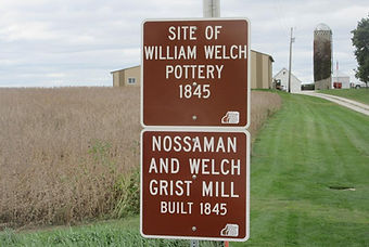
Nossaman & Welch Grist Mill-built in 1845
Location: north side of 216 Pl., west of house #1072. (N 41° 21.986', W 98° 57.476')
This mill was operated by Wellington Nossaman and his father-in-law, William Welch. In her memoir Sarah Nossaman recalls it could grind about 3 pecks of corn an hour using 6 ox power. They ran the mill day and night because often 15 to 20 men would be waiting to have a bushel of corn ground. Sarah fed them by baking bread and preparing whatever game the hunters were able to bring in. Within a few months her work load lessened as two wheat mills were built on the Skunk River.

Nossaman Cabin Site
Location: West side of T-17 at house #1223. (N 41° 20.757', W 92° 54.837')
One of the first cabins built in Marion county by brothers Levi and Wellington Nossaman in the summer of 1843. It was wisely constructed just above the flood plain. A second cabin was built further up the the hill to the north. The two families, each with a three month old baby, moved here when the territory opened in May of 1843. Their wives were sisters, daughters of potter William Welch, who soon moved from Keokuk to join them.
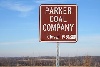
Parker Coal Company
Location: W side 235th Ave 0.4 mile N of Hwy G-71 (N 41* 13.540' W 92* 53.936')
This coal mine was owned and operated by Edward Henry and Marie Martha (Vander Linden) Parker. It closed after his death in 1951. Since the coal mine was part of their farm many of their children assisted in the day to day operations of the mine.
Peace Tree at Harvey
Location: 501 Wabash, Harvey
This sycamore tree, over 100 years old, is the last remnant of Dr. William H.H. Barker's arboretum. His goal was to plant a peace tree at every one of the National Cemeteries in the U.S. The sycamore's white trunk and limbs are a symbol of peace.

Pershing Coal Co. #12
Location: NE Corner of Jct. of G-62 & Polk St. in Pershing. (N 41° 15.777', W 93° 00.402')
This mine, known as The Camp, was approximately 1/2 mile east of Pershing. Over 250 miners worked below ground in coal 4 to 7 ft. thick. Coal was shipped on a Wabash R.R. spur connecting Tracy to Pershing.

Pershing School
Location: 1804 185th Place, Pershing. Township 75 Range 19 Section 35
Although this was not a country school governed by the County School Superintendent, it was a "country" school outside of Pershing, an unincorporated town founded for the nearby coal mines. It was part of the Attica Consolidated School District. There were as many as four teachers for the nine grades. When the school closed in 1947, the children were bused to Attica. In June, 1947, the building was advertised for sale as being 45 x 75 feet, with wing 22 x 80 feet, two story with basement and three furnaces. In October, 1947, the building was razed. This school had a short life of just 25 years.

Plainview School
Location: West side of 240th place, 300 yards north of Vermeer Road. (N 41° 24.999', W 92° 53.415')
Plainview opened in 1875 on a farm owned by J. Merkel. Now the location of Vermeer Corporation, his farm was part of a large section of land purchased by Dominie Scholte. Later the school was moved and rebuilt. Was the school named Plainview because it was in plain view of the surrounding countryside or did its location offer a plain view of that countryside? It closed in 1958.

Pleasant Grove Christian Union Church
Location: 1200 block 132nd Place, Knoxville Township
This church stood directly west of the Greenwood Cemetery. 132nd Place is the gravel road extension of Roche Street in Knoxville. This minor denomination began during the Civil War years In Ohio, in an attempt to unite all Christians with much autonomy for local churches. From a high in 1906, membership nationally dropped in half by 1926. The nearness of this church to Knoxville certainly contributed to its closing. There were many funerals held in this church as reported in the local newspapers during the years the church was open. There is currently a Christian Union Church in Milo in Warren County.
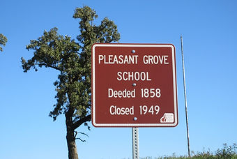
Pleasant Grove School, Summit Township
Location: North side Clemons Dr., 3/4ths mile east of Hwy 14 (N 41* 28.362’, W 93* 05.286’)
Deeded in 1858, Pleasant Grove School was closed in 1949. One of the students who attended this school was the late Gerald Verros, a popular storyteller, who spoke at many events, often telling stories about his school days. One of his stories was about John Steinman who was working with a road crew near the school. When he noticed that the students were using a stick instead of a ball bat, he went to the coal shed to find a piece of wood and an ax to carve a bat for them. He died the next day and the students carved his initials into that special bat. Every student has special memories of their country school days but many are lost because they never tell them.
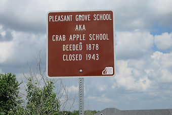
Pleasant Grove School, aka Crab Apple School, Knoxville Township
Location: N.W. corner Hwy G44 & 132nd Place.
This area had a large population already in 1873, when the school statistics show 1 man teacher who was paid $33.33 per month and 1 woman teacher, paid only $20 per month. There were 98 children between the age sof 5 and 21 in this school district, of which 65 were enrolled with an average attendance of 36. Valentine’s Day was an important day for these kids in 1898, as a newspaper article then promoted entertainment of vocal and instrumental music, speeches, dialogues, and a play, all free, “50 cents worth of fun for nothing.” A large box ad appeared in both Knoxville newspapers in May, 1950, advertising the Crab Apple Schoolhouse, size 28 x 38 feet, for sale, along with desks and school equipment.

Pleasant Ridge Christian Church
Location: SW of Corner across from Pleasant Ridge Cemetery on Perry St. Sec. 21-75-20. (N 41° 16.834', W 93° 10.558')
Started in the homes of local residents in the late 1860s, around 1872, the congregation moved into the Hunker Ridge School, a log building, near what was later the Burr Oak School. In 1873 a proper building was erected. Later the church split with some members meeting in the Empire School house and others in the Pleasant Ridge School house. The building was razed in 1942.

Pleasant Ridge School (on 80th)
Location: North side 80th Ave. near center of SW ¼ Sec. 29-75-2. (N 41° 15.979', W 93° 11.340')
This school was built in 1874. Some time after closing, the school was moved to the Marion County Historical Village and restored. It contains period furnishings. Several binders of pictures and information about Marion County country schools can be found in the museum library.

Pleasant Ridge School (on McKimber)
Location: NE of Jct. of McKimber St. and 20th Place. (N 41° 19.245', W 93° 18.558')
Located in the Northwest corner of Franklin township, it was one of three schools named Pleasant Ridge. The foundation of this school is still visible. Closed 1939.

Pleasant Valley School (Frog Pond School)
Location: S. E. corner of junction of Briggs St. and 150th Avenue (N 41* 29.223’, W 93* 08.950’)
This school was nicknamed Frog Pond because of a swampy area in a corner of the schoolyard. There were more snakes than frogs recalls Bernard (Guy) Reeves, former student and retired social studies teacher at Pella Community High School. In February of 1897, one of the most unusual events that happened at school was reported by the local correspondent for the White Walnut, Red Rock township: “At the meeting of the literary society, a most shameful riot occurred at which a number participated, some of which were badly cut up, others seriously bruised, and quite a number hugely scared. Revolvers were drawn, stones were thrown, and false knuckles freely plied.” (Literary societies were attended by adults not the school children ) Guy recalls more typical events such as his first time seeing County Superintendent Sylvia Plotts, dressed in black parading down the aisle. (She was an unforgettable sight.)
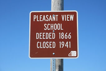
Pleasant View School
Location: West side 160th Place, 1/2 mile South of Jasper County line (N 41* 30.064’, W 93* 02.653’)
Pleasant View School district borders the Jasper County line. It was deeded in 1866 and closed in 1941. There are several schools that share the adjective 'pleasant', but this is the only one that claims to have a pleasant view. Among the teachers are several whose last names reveal their Dutch ancestry. Included in the list are Witzenberg, Vriezelaar, Van Roekel, Hiemstra, Ver Dught, Van Hemert, and Vos.

Plymouth Church
Location: North side of Old Hwy 92 just west of house #1913. (N 41* 18.158’, W 92* 59.008’)
The Plymouth Presbyterian Church was organized October 9, 1869, by several families from Scotland who had settled in the English Settlement area nearby. Ground was purchased from Samuel Breckenridge for $30 and the church building completed November 1871 at a cost of $2800. On December 4, 1966, it was voted to merge the congregation with the First Presbyterian Church in Knoxville. The building was torn down.
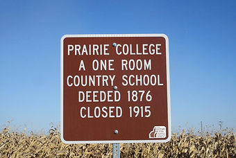
Prairie College
Location: Northeast of Jct. of 195th Place and Old Hwy 92. (N 41° 13.144', W 93° 03.720')
Its name makes this country school sound like a building of higher education out in the middle of nowhere. It was just a typical country school whose board bought a half acre of land for $25 from P. and Mary Applegate in 1876. It consolidated into the Attica district in 1915.

Prairie Lake
Location: Northside of 216th Place west of house #1072, N41* 21.986’, W 92* 57.476’
Many of the first settlers to Marion county in 1843 laid claim to land that was close to the Des Moines River. Across the river bottom on the north side of the river was a slough thought to be a former river channel which they called Prairie Lake or, sometimes, Mud Lake. It gave its name to Lake Prairie township and was a source for fish, ice blocks in the winter, and, unfortunately, a huge mosquito population.

Red Rock Coal Co.
Location: At Jct. of D St. SW & SW 2nd St. in Melcher. (N 41° 13.142', W 93° 14.670')
Operating from 1917 to 1931, it was approximately 1/4 mile west of the Catholic Church in Melcher. Charles Anderson was the superintendent of this good producer.

Red Rock Line crossed near here
Location: north side of 216 Pl., west of house #1072. (N 41° 21.986', W 98° 57.476')
The Red Rock line was the result of an 1842 treaty that distinguished Indian territory from the settler’s territory. The Sac and Fox Indians agreed to let the Whites live in the land east of a North/South line running through the red rocks on the Des Moines River. The east half of of this line was open for settlement on May 1, 1843, and the territory west of the dividing line was open Oct. 11, 1845. In the meantime, the Indians and settlers opened a trading post which quickly developed into the town of Red Rock which now lies under the waters of Lake Red Rock.

Red Rock Old Town (under water)
Location: SW corner of Jct. of Erbe Drive & 124th Ave. (N 41° 26.170', W 93° 06.895')
Red Rock derived its name from the red sandstone bluffs along the Des Moines River. Situated on the east side of the territorial dividing line that opened on May 2, 1843, and the west side which opened on Oct 11, 1845, it became a draw for people wanting to move further west. Entrepreneurs quickly established trading posts to serve Indians, settlers, and those fleeing from the law. Many of the descendants of the early Red Rock residents remained in the area and take pride in the once notorious little village now under Red Rock Lake.

Rees School
Location: South of Gear St. South side of #949. (N 41° 24.882', W 93° 10.078')
Rees School takes its name from several farm families in the district with the surname Rees. Due to declining population it closed in 1946.

Richland School
Location: 1800 block Coolidge St., 2 miles east of Otley. Summit Township, T77 R19 Sec 24 n.e. ¼ of n.w. ¼
In 1925 there were 8 girls in one class.

Rising Star School
Location: 500 ft West of Hwy #5 on East side of 150th Pl. (N 41° 17.763', W 93° 04.292')
No one knows the origin of the name but one of its former students said the name made us feel like we were all rising stars. The district made good use of the school building for many after school activities. There was a furnace in the cloakroom which meant no students or teachers had to endure the smell of drying wool mittens. Closed 1958.

Riverfront Town Site of Ora Dell (Pinchey)
Location: NE corner of 60th Ave. and G-40. (N 41° 23.137', W 93° 13.983')
Pinchey Bottoms near here. Oral Dell was a hamlet in steam boating days. (The last boat passed in 1865) There are many versions of why it was called Pinchey, all centered around a shopkeeper who would remove a pinch of sugar or pinch a green bean in two to get the correct measurement. There were two general stores one of which had a huckster wagon which delivered groceries in exchange for eggs and produce. The mud flats along the river bottom acquired the name Pinchey Bottoms. The area is considered a prime birding site.
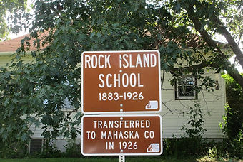
Rock Island School
Location: East side 250th Ave. near NE Corner Sec. 12-75-18. (N 41° 19.284', W 92° 52.242')
On the east side of the county line this school was under the jurisdiction of Marion County until 1925 when it was transferred to Scott township in Mahaska County. It closed in 1958. It was split off from the original Porterville district. A railroad bordered the north side of the school grounds making for lots of distractions during the day and tramps sleeping in the building at night. Bars were installed on the windows to keep them from breaking in.

Round Barn Road
Locations: East of 60th Ave. on Rutledge St. (N 41° 13.995', W 93° 13.921'); West of 80th Ave. on Rutledge St. (N 41° 13.998', W 93° 11.698')
The name comes via the round barn on Rutledge St. The barn is privately owned and not open for touring. The barn was built in 1911 and is 76 ft round.

Round Grove School
Location: South side Upton St. 1/4th mile east of 140th Ave. (N 41* 11.818’, W 93* 04.547’)
This school opened in 1880 and closed in 1943. For many years it was the practice of rural teachers to prepare a booklet with their picture, names of the children, and a bit of poetry to give to each child at the end of the year. Souvenir booklets from 1905 and 1906 give a clue as to how much the attendance varied from year to year. At that time there were many tenant farmers, so some children attended several different country schools before completing the 8th grade.

Salem School
Location: SE corner of 94th Pl, 1/2 mile north of Quebec St. (N 41° 15.328', W 93° 10.221')
It’s a mystery. Does anyone know why a school on the midwest prairie was named after an eastern seaport founded in 1626? Students who attended school there in 1935 were named Hall, Lenig, Verwers, Rinehart, Hedrick, Ricky, Brees and Bebout. Closed 1936.

Sandridge School
Location: Northeast corner of Jct. of 240th Ave. & Blue St. (N 41° 29.460', W 92° 52.566')
At least three different buildings served this school. The last one, built after a 1944 fire, had big improvements of an oil furnace, running water, Rolscreen windows, and a cement floored basement. Former students who attended during the first decade of the 1900’s wrote that the school with attached coal shed sat on the north side of an acre of ground. On the south side was a small barn to house a burro and, later, ponies. Closed 1960.

Scott School
Location: South side of Pratt Dr. about 400 ft. west of house #1512. (N 41*15.651’, W 93* 03.384’)
Often called the Valley School it was located in a pleasant valley filled with trees and birdsong. There was no well on the property which meant a student would carry a pail up the hill each day to get water from a farm. Nearby was the Valley Chapel which has been moved to the Marion County Historical Village.

Shiloh School
Location: Jct. Hwy. 5 and 202nd Place. (N 41° 12.655', W 92° 57.715')
A two-story building that was one of the largest country schools in the county, it was built to accommodate an influx of coal mining families. It was a progressive district electing two women to serve on its board of directors decades before women were given the right to vote. Closed 1953.

Silver Grove School
Location: 1/8 mile South of #702 190th Ave. - East side. (N 41° 25.215', W 92° 59.158')
This district was once divided into two schools named East Silver Grove and West Silver Grove. When East closed in 1921 all the students attended one school, Silver Grove.The first teacher known to have taught, probably between 1858-1861, had the fitting Dutch name of Louisa Boekenoogen (eyes in a book). The 1877 records show a district population of 160 children between the ages of 5 and 21. Closed 1961.

Simmons School (Bluebird School)
Location: East side 140th Ave., 1200’ south of Virginia St. ( N 41*10.340’, W 93* 04.848’)
This school opened in 1891 and closed in 1951. Margaret Gee who started school in the Elm Grove district where she lived, attended Bluebird when her home school closed temporarily. She said the school was sometimes so cold that she had to keep overshoes on her feet to keep from getting frostbitten. At that time one large family made up most of the students at Bluebird. A memorable event for Margaret was when someone came to the school with a car radio and told the students who had been elected.

South Porterville School
Location: East side 228th Ave. in the NW ¼ NW ¼ Sec. 2-75-18. (N 41° 19.896', W 92° 54.334')
Located just a few yards from the Des Moines River in a heavily timbered area, the school came into existence in 1877 as a split off from the original Porterville School. On Sundays it served as a Sunday School for the neighborhood families. By 1943 there were so few students it again merged with North Porterville, creating a very long distance for some students to walk.

Spring Hill School
Location: NE of Jct. Highway 14 and Pratt Drive. (N 41° 15.550', W 93° 06.793')
Dixie Cornell Gebhardt, designer of the Iowa flag, taught at this school in 1886. Ninety-three students were enrolled in this school in 1892. Fortunately they didn't all attend every day. Closed 1957.

Springdale Community Church
Location: SW corner of Jct. of Nixon St. and 20th Place. (N 41° 27.900', W 93° 18.956')
This was a small church which had the look and size of a typical country school. As a neighborhood church it served the needs of more than one denomination. The church was built as a Methodist Church in 1895 and closed in 1956.
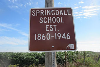
Springdale School
Location: NE corner of Jct. of Nixon St. and 20th Ave. (N 41° 17.508', W 93° 18.564')
In many country schools two or three large farm families might make up most of the school population. All eight children of the Anthony family attended this school which was across the road from their home. Marjorie, the youngest, expressed the feelings of many with the words, “I think the country schools provided a good education. I am glad I had a part of that experience.” The school which was established in 1860. closed in the spring of 1947.

Springfield School
Location: West side of 155th Place, 1/2 mile south of G-78. (N 41° 11.821', W 93° 03.108')
This was a typical country school where many students said they felt like they were part of a family. The only difference being that many of the residents were renters so the “family” classmates changed often. On Halloween the school board didn’t have to worry about overturned toilets. The WPA had constructed two sturdy outdoor units bolted to a cement base.

Stagecoach Stop
243rd Place, west of BNSF Railroad, Section 24 northwest of Tracy
This road is closed so the sign is placed 860 feet east of the actual location. Abie Davis and Margaret Gee did much research on this site. It was a relay station between Oskaloosa and Knoxville. Abie took photographs of some artifacts found here such as part of a horseshoe, a carriage bolt, and a chisel.
Western Stage Company’s wagons were wood, painted brick red with yellow lettering. Fare averaged 5 to 7 cents a mile. Mail contracts were a primary source of revenue. The coming of the railroads ended the stagecoach era.
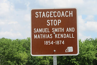
Stagecoach Stop
Location: North side of Van Buren Dr., just west of North Cedar Creek. (N 41° 11.482', W 92° 59.508')
Matthias Kendall bought the property on which the house stands from Samuel Smith. Built with walnut lumber the house was designed for cross ventilation with rooms set off a central hallway on both floors. A 28 by 32 ft. attic space with two windows provided additional sleeping space. The road past the house is not in the same location as it was in stage coach era.

Stagecoach Stop
1768 Hwy 163, southeast of Otley
This is the 4th sign marking stagecoach stops in Marion County. A picture of the hotel which stood at this location on the present Van Zee farm survives. Before the railroads were built, this was the best public land transportation. These signs represent the earliest history of our county.
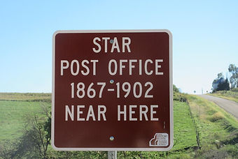
Star Post Office
Location: SE corner of Newbold St. and 50th Ave. (N 41° 17.929', W 93° 15.123')
This post office which existed from 1867-1902 was probably in this location to serve the needs of the rural folks who were too far from the nearest town. In the early years there were a number of temporary post offices, often in someone’s country home. There is one reference to this one being on the Rousseau route.

Stringtown Road
Location: North side of G-40 West of Hwy. 14 (N 41° 24.102', W 93° 06.663'); South side of G-40 East of 50th Place. (N 41° 23.142', W 93° 15.121')
The name suggests that there was once a town along this road. However, there was never a cluster of homes, only single farm houses strung out along the road. Hence the name Stringtown.

Stringtown School
Location: North side G-40, 0.75 miles East of 50th Place. (N 41° 23.136', W 93° 14.205')
Along with all but two other schools in Pleasant Grove Township, it was consolidated into the Pleasantville school district in the fall of 1915. Familiar names of its country school teachers include Spalti, De Witt, Billingsley, and Worthington. Closed 1915.

Stumptown Settlement
Location: 333 Jersey Dr., southwest of Pleasantville
This community was known for a sorghum mill, animal hides, hired hands and the Stumptown String Band. The bass fiddle stenciled with the Band's name still survives.

Summit School
Location: West side of 152nd Place about 200 ft. north of house # 319. ( N 41* 28.807’, W 93* 03.574’)
The school was thought to have been organized in the 1860’s and burned down in the fall of 1921. While it was being rebuilt students attended school in a small shop on the Bart Van Dusseldorp farm. Located in an area of Dutch settlement, throughout its history many of its teachers as well as the students were of Dutch ancestry.

Sunnyside School
Location: NE Corner Jct. 60th Ave and McKimber St. (N 41° 19.237', W 93° 13.959')
Nestled in a valley at the bottom of four hills, Sunnyside began in the mid 1800's a quarter mile to the west. In 1939, it moved down the hill into a new building that provided the three R's plus music, art, Christmas programs, and a community center. Students enjoyed the outdoors most, from coasting the hills to pole-vaulting over Hawk Run Creek and walking the nature tours led by dedicated teachers. Closed 1949.

Thornburgh Stagecoach Stop
Location: 114 Hwy 5, just inside the Marion County line south of Swan.
The Sixth General Assembly of the Iowa Legislature authorized a mail route on a stagecoach line from Knoxville to Pleasantville, thence via Wheeling to the county line between Marion and Warren near James Thornburgh's, there connecting with the State road leading to Fort Des Moines. An old map of stagecoach routes including Marion County shows this line. The 1850s and 1860s were the years stagecoaches ran until the railroads took over their business. Iona White of Knoxville wrote a paper on Stage Lines and Stops of Marion County which shows the Thornburgh house as it looked in 1980.
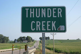
Thunder Creek
Locations: NW corner of bridge over Thunder Creek on T-14 (N 41° 26.476', W 92° 55.420'); and SE corner of bridge over Thunder Creek on T-14. (N 41° 26.424', W 92° 55.419')
Thunder Creek has its origin in Summit township and empties into the South Skunk River at the Marion / Mahaska County line. There are lots of creeks called Thunder Creek, perhaps because of the loud noise they make while roaring through the landscape. The Thunder Creek Hawks is a Marion County 4H Club named in honor of the little stream.

Union Chapel M.E. Church
Location: North Vermont St., 0.25 mile east of 65th Ave (N 41* 10.938 ‘, W 93* 13.054)
On Sept 4, 1924, the Union Chapel Church offered it's 30 x 40 frame building (in fair condition). "Owing to the fact that the members of their church are not sufficient to maintain it, it has been decided to sell the building and its contents of seats, organ, and other equipment including a mixed gasoline light plant in good condition and one almost new heating plant." In Feb.7, 1906 Knoxville Express readers were told money had been subscribed for painting the chapel, "which will be done as soon as spring opens. Lately the Sunday School hours was changed from morning to two o’clock in the afternoon on preaching day. By June 13," 1906 newspaper reports that the painting had been completed.

Union Coal Co. # 5
Location: East side T-15 & South side Stone St. on West edge of Flagler. (N 41° 19.579', W 93° 01.515')
Much of the coal was 7 to 8 ft. deep, enabling large mules, usually 8, to go anywhere in this mine. The capacity was 180 tons of coal per day. It was open from 1880 to 1889. In 1881 it produced the most coal in Marion Co.

Union School, Clay Township
Location: North side of Quaker Dr, 1/4 mile East of Hwy T-15 ( N 41* 15.113’, W 92* 57.121’)
For many years the students were a mix of predominately Dutch farmers and various other nationalities. Several of these students who attended in the 1930’s and 40’s provided many fond memories for the book One Room Fit All, The Country Schools of Marion County, Iowa. The school closed in the spring of 1957 and the back of sign notes that it was funded by the alumni.
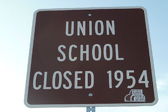
Union School, Union Township
Location: South side G-40 Jct. with 110th Ave. (N 41° 24.012', W 93° 08.315')
Union school with 8 windows on its west side was a local landmark for many years. Much to the disappointment of former students who still live in the area, the school deteriorated so much that the landowner burnt it down in the fall of 2009. Closed 1954.

Union School, Washington Township
Location: 2201 80th Ave., ¾ mile south of Hwy G76
Now the site of a new home, this school had a beautiful view of the Long Branch valley below. A stove stood in the middle of the room yet into the 1950s. Water was obtained by going to a neighbor. The last teacher, Mrs.Marlene Stevenson, 1952-1958, picked up several kids on the way to school. Her car had a homemade bus sign on the bumper. In 1873, the first year school statistics are available, the man teacher taught 6 months and was paid $30 per month. There were 43 children between the ages of 5 and 21, of which 25 were enrolled with an average attendance of just 12. There were 4 boys and 1 girl between the ages of 7 and 14 who were not enrolled in any school.
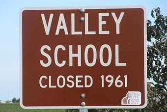
Valley School
Location: North side of Jct .of Illinois St. & 245th Ave. (N 41° 22.701', W 92° 52.835')
In 1926 the old school building was torn down and replaced with a new one with basement and furnace. During World War II an airport for training pilots was located in a nearby field South of the school. For five years from the fall of 1946 to 1951 the school was temporarily closed and even rented out to to a pair of newlyweds for a four month period. It closed officially in 1961.

Valley View School
Location: Northeast corner of 180th Ave. & Beardsley St., 1 ½ miles east and 2 miles north of Otley. Summit Township, T77 R19 Sec 1, s.w. corner.
One year Mary Hiemstra had a little lamb which followed her to school, which brought to life the nursery rhyme about Mary and her lamb. She was the only girl in school for a time.

Van Wyk Drive
Location: South side Dakota Dr. just east of 150th Ave. (N 41* 27.489’, W 92* 53.697’ )
This sign was put up at the request of Elsie Van Wyk Blom. Once there were 3 farms belonging to Van Wyk siblings along the road. Those of Harold Van Wyk, Don and Elsie Van Wyk Blom, and Arie and Tresie Van Wyk Van Weelden. For many years there was a sign designating Van Wyk Road until the REC put in telephone poles and it was removed. As Elsie said, “We wanted our sign back.” You may have noticed that among the Dutch population there are many with the last name Van Wyk. There’s a reason for that as one of Elsie ancestors was married 3 times, His first two wives died and the last one he married already had offspring bringing the total number of his children to 23.

Victory School
Location: Southeast corner of Oregon Dr. & 180th Avenue, 1 mile north of Pershing. Knoxville Township, T75 R19 Sec 24, n.w. corner of s.w. ¼
One of five schools organized in 1920 into the Victory Central Consolidated School District, the other four being, Vigilance, Union, McMillen, and Fairview (Clay Twp.) Like many country schools, it did not have electricity. Windows on the west and east sides provided light along with kerosene lamps in brackets on the walls.

Wabash Bridge & Durham’s Ferry
Location: SW Corner of Jct. of T-17 and 216th Place. (N 41° 20.700', W 92° 56.351')
In 1846 David Durham was given a license “to keep a ferry” across the Des Moines River at Durham’s Ford. He could charge 25 cents for a 1 or 2 horse drawn wagon and 50 cents for a 4 horse drawn wagon. This was one of the busiest ferries across the Des Moines River carrying settlers moving West and those heading for the Gold Rush of 1849. Sometimes the wagons were lined up for days waiting to cross the river. In 1882 the Wabash bridge was built. It became the property of Marion County some time after 1946 and is known as “the dollar bridge.”

Washington School
Location: North side of Kennedy St. just east of 150th Ave. (N 41* 20.974’, W 93* 03.735’)
In August of 2010, several former students gathered at the schoolhouse in the Marion County Historical Village for a reunion organized by Roberta Fast Dennison. They spoke of playing favorite games. Annie, Annie Over was first, followed by softball. Betty Roff Beal told how she used to ride her pony to school, and now, at age 82, she still enjoyed riding a mule. Carol Tonda Black reflected that on the first day of school she decided at age 4 she wanted to become a teacher like her teacher, Frances Thompson. And she did.

Wesley Methodist Chapel
Location: North side G-76, 600 ft. east of 155th Place (N 41*12.260 ‘, W 93* 02.952)
This church was deeded in 1875 and sold in 1910. Rather than having an auction to sell the building and contents here’s how they were offered for disposal in the Jan 19, 1910, Journal Express: "Church for Sale, To Whom It May Concern: The Methodist Church in Indiana township known as Wesley chapel has ceased to be used by the congregation as a place of public worship and the building with fixtures will be sold. The interior consists of seats, good organ, chairs, lamps, stove, etc. These are all in good condition and anyone needing anything in this line should not fail to call and inspect these. Will you place a bid on the building and contents? Put separate bid on the fixtures. Send sealed bids to one of the undersigned., A. F. Maddy, Knoxville, Rt. 1; Stephen Smith, Columbia; J. I. Chambers, Knoxville. Rt 8."
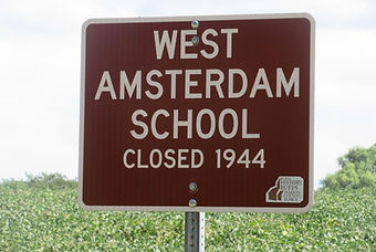
West Amsterdam School
Location: On SE corner on Hempstead Dr. one mile West of T-15. (N 41° 23.335', W 92° 58.741')
Built in 1882, the 18‘ by 26‘ building sat on a bluff overlooking the Des Moines River. It was identical to the East Amsterdam building which is on its original site and serves as a museum. When the school closed in 1944 the remaining students attended East Amsterdam. The name gives a clue that this farming community was an early Dutch settlement.

West Durham Bridge
Location: 195th Place just north of McKimber on the line between Sections 6 & 7 Clay Township
This bridge crosses English Creek. A Knoxville Express, June 13, 1946 states “From the standpoint of pictures-quinces (sic) the West Durham bridge ranks number one in Marion County . It is a romantic picture either looking under the overarching elms into its south entrance or looking downstream from the bend in the bank of English Creek.” The June 25, 1878 issue of the Pella Blade has a story about a shooting which took place on the bridge. Two innocent men returning from a temperance meeting were shot due to mistaken identity by two sentries stationed at the covered bridge.
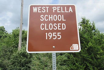
West Pella School
Location: NE Corner of Erbe St. and 80th Ave. (N 41° 26.173', W 93° 13.988')
Miles from the town of Pella, the name probably stems from the three Dutch families who settled here in the 1850’s. In 1872 it was a large school with 49 students enrolled. The county superintendent was impressed with the zeal of the teacher whom he described as “having good order”. Closed 1955.

Wheeling
Location: SE Jct. of Hwy. 5 and Geneva Dr. (N 41° 25.24', W 93° 17.974')
An old town named after Wheeling, West Virginia, it was surveyed in 1851. It had a post office from 1852-1884, a blacksmith shop, school and the first Methodist Protestant Church in the county. In 1875 there was a population of 175. As people left, most buildings from the little hamlet were moved to Swan or Pleasantville and the church was converted into a barn.
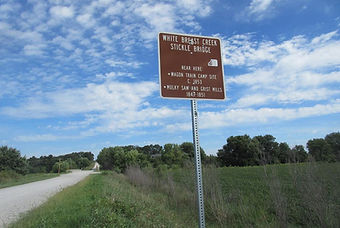
White Breast Creek & Stickle Bridge
Locations: 100 yds north of bridge on 70th Ave. (N 41° 16.784', W 93° 12.817') and 100 yds south of bridge on 70th Ave. (N 41° 17.500', W 93° 12.817')
One legend says Whitebreast was named by Native Americans to honor a bear with a white patch on its chest. In the 1930’s Whitebreast was straightened away from the high curved sandstone banks southeast of the bridge. Though it still flows East to join the Des Moines River and Lake Red Rock, it does not resemble the creek that ran the Mulky Mills and stopped the 1853 wagon train. Stickle Bridge, named for an early neighborhood family, was built in 1898 and was replaced by a high-frame steel bridge when the creek was straightened in the early 1930’s. In 1872, two people drowned while trying to cross Mulky Ford. The current bridge is from the 1980’s. The Mulky Mills, built by G.Z. Mulky and Sarah Schlotterback Mulky of Indiana in 1849, were in the bend of the old creek. The sawmill was constructed of material transported by oxen from Keokuk. The first in the area, it averaged 2,500 feet/day. Next came a grist mill which provided cornmeal for patrons from 30 miles around until a flood in 1851 required a rescue by canoe and destroyed both mills. Later, in 1853, a wagon train was stranded on the bluffs above Whitebreast where they wintered over. Disease, perhaps measles or pneumonia, left eleven dead. One grave was inscribed “Elizabeth P. Glenn, died March 1853, 9 days old.” A little over 100 years later a man named Glenn came to the farm and asked for the “Glenn Cemetery.” Marcus Stickle showed him the site and helped him use his cement mixer to make headstones for the other graves.

William Welch Pottery site
Location: South side of Keokuk Dr. at Jct. with 235th Ave. (N 41° 20.908', W 92° 53.967')
Mr. Welch built the first pottery site in Iowa in Van Buren Co. in 1836. He followed his daughters, the wives of Levi and Wellington Nossaman to Marion Co. in 1845. He operated a pottery works and a gristmill. Both pottery shards and arrow heads can be found on this site.

Willow Grove School
Location: South side Rutledge St., 1000’ east of 130th Place (N 41* 13.994’, W 93* 05.752’)
This school was deeded in 1858 and closed in 1955. We have not found much information about this school, except there are some familiar names among the teachers that taught there: Nannie and Georgia Applegate, Stella Brubaker, Kathryn and Mildred Bybee, Lois Agan, and Virginia Robuck.
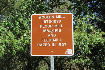
Woolen Mill
Location: NE of Jct. of Oak St. (Virginia Dr.) and Mill St. in Marysville. (N 41° 10.852', W 92° 57.076')
The history of this mill shows the evolution of changing times and needs of a community. The original building constructed of native oak on a foundation of native stone served as a woolen mill from 1872-1879. People came from long distances to have their wool cleaned, carded and made into yarn. In 1881 with an addition to the building it served as a flour mill until 1918. Brothers Jake and C.C. Kendall bought wheat from Kansas City as well as locally. It’s last use as a mill was for grinding feed. In 1937 it was torn down and its boards sold for 2nd hand lumber. While the mill is only a memory isn’t it nice to imagine that some of those boards may still be serving a useful purpose?